Ocean Beach –
Kelly’s Cove Running / Hiking Guide
[Update Summer 2014 - The beach apron -or the hardpack near the water line - is steep and scalloped making for a challanging run in places. The north end at high tide is quite steep and soft. Would advise an alternate route until the wind storms return and level things out.]
Starting at
Kelly’s Cove you can go three directions for 3 completely different
experiences.
The Beach Experience
– South
On the beach - 1a & 1b (refer to aerial photo below).
Ocean Beach proper (1a) is an exceptional running venue for several reasons. First, it
is relatively flat meaning the height differential between the feet is
negligible. So unlike many beaches along the Gulf
Coast or Atlantic
which have steep slopes, here, ankle, knee and hip joints are spared the stress
of differential impact. Second, Ocean
Beach is shell free with
few if any hazards. There are a few small stones but these are polished and
mostly flat. And third, the air
temperature here stays fairly close to the 53 degree water temperature.
The fine
silt-like sand packs hard in a 10-50 yard wide apron between the water and
softer sand. This surface is idea for running
barefoot and gives enough to mitigate jarring.
The softer
sands beyond the wash zone (1b) provide
the perfect conditions for isometric and oblique muscle conditioning. Go easy
if you are new to soft sand
running. Consider running barefoot or with beach booties as the sand will
fill up your sneakers beyond a few hundred yards.
From the
rocks on the north end of the beach at Kelly’s Cove to the rocks at the south
end of the beach near Ft.
Funston is a distance of
3 miles exactly. So out and back is an even 6.
The stop lights on Great
Highway
are ¼ mile apart and can be used to mark
off your progress or an interval workout.
Bear in mind
the winds prevail from the Northwest and generally pick up as the day progresses.
The beach is deserted in stretches in the AM expect for the occasional
dog-walker or surfer. Evenings and weekends evidence the bulk of users,
especially along the north stretch between Judah and Kelly’s Cove.
Dogs are
usually off-leash but not normally a problem as there is just too much
distraction for them including other dogs, birds and tennis balls. During peak
use, the beach is never so populated as to impede your workout.
A big part
of the Ocean Beach running experience is the sound
and beauty of the Pacific wave releasing energy acquired thousands of miles
away. The drone and repetition of the breaking waves is ideal for those who use
running as a meditation. The ‘striping away’ of the extemporaneous clutter is
hastened by the natural drama and the infinite sea beyond.
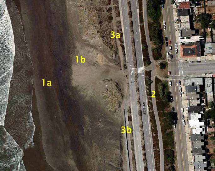
Linear Park – 2
For those
who prefer paving, there is an 80’ wide linear park along the east side of Great Highway
that
is bisected by a gently meandering asphalt trail wide enough to accommodate
bikers and runners (5’). Additionally there is a ~1’ wide sand apron adjacent
to the trail that provides less impact. The park consists mostly of low scale
coastal scrub bushes and trees, grasses and the ever-flowering ice plant.
The trail is
approximately 2.75 miles from Balboa on the north end of Ocean Beach
to Sloat on the south end, so round trip is 5.5 miles. It is broken only by the
streets that flank Golden Gate
Park and feed into Great Highway. At
these intersections there are lights and potentially, a 40-60 second wait.
Terminating
at the Great Highway
are alphabetical streets named after Spanish generals. Anza, Balboa,
Cabrillo et.al are to the north and Rivera,
Santiago, Taraval et. al. are to the south.
One block
off Great Highway
at the intersection of Balboa and La Playa are steps that rise 180’ to the top of Sutro Heights.
Adding this to your out-and-back run will yield an even 6 miles and a good
anaerobic burn to punctuate your workout.
The paved
trail does not offer the both spectacular and sublime experience of running
along the very edge of the western world.
It does however offer a well-defined paved course and the appearance of
safety being flanked by a residential district on one side and a moderately
busy 4 lane road on the other. Perhaps for these reasons it is well used from
morning until hours after the sun has set.
Again you
can mark off your progress and intervals by the stoplights along
Great Highway between Judah and Sloat.
These lights are approximately .25 miles apart.
The linear
park is also adjacent to the commercial district at the end of Judah (where
the light-rail trains turn around). Here you can relax after your workout
sipping an iced coffee from Java
Beach
or an organic
smoothie from Judalicious several blocks in. See below.
Dune Trail - 3a & 3b
On the beach
(west) side of Great Highway, there is boardwalk on the north end which
transitions to a sand dune trail (3a) from Lincoln to Noriega and then back to
boardwalk to Santiago then back to sand until it’s termination at Sloat. The
boardwalks (3b) are broad, concrete
seawalls and connect visually with the surf. The north boardwalk is quite
active while stretches to the south are less populated but very safe given your
proximity to the highway.
The sand
portions of the trail vary in density from moderately packed to soft. If the
wind has been blowing hard, drifts will cover them in places but these are
easily traversed.
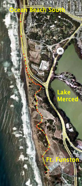 Fort
Funston
Fort
Funston
If you wish
to increase the length of your run or explore more varied terrain, continue
south along Great Highway
to Fort Funston
, a former Nike missile base.
There is a wide bike lane to escape the accelerating traffic and you only have to run a few hundred yards along the highway before you can get back on the trail. Except for the parking area, Ft. Funston is in its natural state and as the name implies
fun to explore. Trails criss-cross this park and will take you along the cliffs and through former bunkers.
From the rock termination at the south end of
Ocean Beach
to the scenic to the Funston overlook (where the hang gliders launch) is 1.6
miles or 3.2 miles round trip or 9.2 from Kelly’s Cove.
One caveat: during astronomically low tides, the beach below Funston is accessible and can add another mile or so to your run. There are some debris spots (old gun turrets, concrete, etc.) but they are easily navigable even in your bare feet. Check the tide charts. If low tide is -1 foot or more, the beach will be exposed. Just note which direction it's moving when you venture past the rocks as the hike out, if you get trapped by the water, can be challenging.
Lake
Merced
For long
distance runners and marathoners, consider adding a loop around Lake Merced
.
This 4.5 mile loop is popular with walkers, bikers, roller-bladers and
runners who share a broad paved path next to the lake. Evenings are quite busy especially with the stroller set.
Combining
the Ocean Beach,
Ft. Funston
and Lake Merced
loops, one can get a 13.7 mile round-trip
run almost entirely automobile free. Fog is often a factor in the summer so
some areas can be socked in with low visibility and if the wind is blowing, you can loose heat fast so best to head out with a piece of fleece or wind breaker. There are public restrooms at
the South end of the beach, at Judah and Taraval as well as Funston and Merced.
The Park Experience
– East
Golden Gate National Park is 3
miles long by ½ mile wide and offers a variety of running / hiking experiences
from sidewalks and paved trails to single track dirt trails. JFK Drive
on the north and South/MLK
Drives on the south yield up to a ~7.4 mile loop (includes a stretch on Great Highway). The loop around Stow
Lake adds another mile. There is no shortage of interesting and spectacular
moments in the park. Gardens, buffalo, water falls, carefully manicured
Arcadian landscapes, old stone bridges and festival-like gatherings make GGP
one of the most interesting recreational venues on the west coast and a great
place to run. If you area’t familiar with the park, print out or study a map
before you take off as the serpentine roads and trails can throw you for, and
into a loop. And if you are venturing into the park on a a summer or fall weekend, check the Park event calendar as music festivals and other large gatherings can impede your workout..
The change
in elevation from east to west is approximately 300’ which is mild
spread across the 3 miles. However, there are areas like Strawberry Hill at
Stow Lake
where you can do hill intervals.
There is a
single track trail that runs between South
Drive and Lincoln. This is a good alternative to
the pavement although beware of the exposed roots and other tripping hazards.
Another
runner’s amenity is Kezar Stadium and its all weather track at the south east
corner of the Park. Here you can do laps on the track or on the 0.4 mile (700
yard) ring around the upper terrace. The track is open to the public most of the time including every morning.
Beyond Golden Gate Park
If you wish
to add mileage or explore the urban areas around the park consider the
following:
The Panhandle
This is a
sliver of park at the east end of GGP and continues for another ¾ mile east before
terminating at
Baker Street.
Meandering paths accommodate a busy stream of bike and pedestrian traffic with
only one interruption at Masonic.
Buena
Vista Park
At the east
terminus of the Panhandle, turn right and run up the hill 2 blocks to
Buena Vista Park
.
A short but steep climb to the top yields the ‘good views’ advertised by its name. From the Panhandle to the top of
Buena Vista
is ~0.5 miles so a roundtrip loop
is another mile adding a total of 2.5 mostly automobile-free miles beyond GGP. If you want to add a bit of flavor to your run and you don't mind negotiating dense, slow-moving masses of humanity, return from Buena Vista via Haight Street.
Twin
Peaks Park
For those
runners seeking a serious hill burn, go south on
Stanyan Street
(right out of the park if you're heading into town) at the park’s east
terminus and run up the hill until it dead-ends into Belgrave Ave. Beware the
grades at the top of Belgrave are STEEP! At the top, go left until it dead-ends
into Tank
Hill. Go up the steps for yet another stunning panorama view of the
downtown. At the top go right and out the back of the hill, down the wooden
steps on to Twin Peaks Blvd. Follow Twin Peaks Blvd as it turns left snakes up to
one of the highest points on the
Peninsula
.
Again, expect more stunning 360 degree panoramas of the entire bay. Also be
prepared for brisk winds. If you still haven’t had enough, traverse up,
over and down the twin peaks and finally over the third minor peak. Round trip
from Kelly’s Cove to the top of the south peak is ~11 miles and a 900 foot
change of elevation most of which is achieved in the 2 miles between the Kezar
Stadium and the Peaks.
The Coastal Forest Experience – North
Ocean Beach is punctuated on the north end by
the famous Cliff House Restaurant and the Sutro Bath ruins. Head up the hill to
Cliff House and follow Point Lobos
Road past Louis’ Restaurant and make a left at the
large parking area. This will launch you into
Point Lobos
and Lands
End (THE place, not the catalog!) and one of the Bay Area’s best
kept secrets. From here there is a
coastal trail runs along the cliffs and will take you through the cypress and
scrub past Seal Rock Beach. The 1.5 mile long Lands End coast trail is paved
initially then changes to hard pack dirt. It is well marked and has stairs in
the steep sections but is quite navigatable at speed. There are numerous opportunities to explore
side trails and attractions including the Camino del Mar / Ft. Miley
overlook near the beginning of the trail. The trail offers more spectacular
views of the Marin Headlands and eventually, the
Golden Gate
Bridge
.
Beyond Lands End
Lands End
Trail terminates on the north end at El Camino del Mar and the uber-swanky
neighborhood of Sea Cliff. Continue along El Camino for .6 miles and you will
find yourself in The Presidio.
From her you can divert down to
China
or Baker Beach
or continue on to the Golden Gate
Bridge or Crissy Field.
For those looking to for a good marathon work out, consider skirting Fort Mason
east of Crissy, spinning through Fisherman’s Wharf and connecting up to the
Embarcadero. Here are some distances:
Kelly’s Cove
to the Lands End Trail terminus at El Camino del Mar: 2 miles
Kelly’s Cove
to Baker Beach: 3 miles
Kelly’s Cove
to Golden Gate Bridge approach: 4.3 miles
Kelly’s Cove
to scenic overlook on Marin Side: 6 miles
Kelly’s Cove
to Crissy Field: 6 miles
Kelly’s Cove
to Fisherman’s Wharf: 8 miles
Kelly’s Cove
to the Ferry Building
at Embarcadero: 10 miles (and take the N Judah
back!)
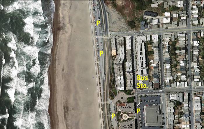
Getting to at
Ocean Beach
– Kelly’s Cove
Most of the City uses either the N Judah light-rail train or the buses to visit Ocean Beach. The N train terminates at the end of Judah which is 1 mile south of Kelly's Cove. Buses feed through the avenues of the Outer Richmond and Outer Sunset terminating at many points along the 3 mile stretch. If you arrive by car, there are
several large lots along
Great
Highway
shown below. On-street parking is also an
option in the outer avenues and along the general streets. Even during large events, parking is always available..
Combining
Experiences
Beginning at
Kelly’s Cove and staying within the bounds of Ocean
Beach, Golden Gate Park
or Lands End, it is possible to design a 20+ mile run / hike loop free of
automobile traffic (less intersections) and without retracing your steps. Restrooms and drinking fountains are
sprinkled throughout GGP and along
Great
Highway.
Post Workout Reward
Within a 5
minute walk of Kelly’s Cove you can:
Imbibe
handcrafted beers and down some protein bites at Beach / Park Chalet.
Grab a
sandwich or the daily special at Freddy’s
Deli.
Pick up your
beach picnic supplies at the Safeway.
Snag a
Latvian beer or exotic chocolate at Eurpora Express
grocery.
Treat
yourself to a gourmet meal or classic cocktail at the historic and the highly rated
Cliff House.
If you want
to venture a little further afield consider the 1 mile trek to the south (15
minute walk) is the Judah Street Outer Sunset business district. A sampling
includes:
Java Beach Cafe
Other Avenues Grocery
Judalicious
Juice Bar
Beach Burrito
Sea
Breeze Cafe
Happy bipedalling!